
3D Laser Scanning
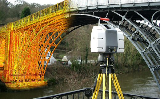
3D scanning is the process of capturing digital information about the shape of an object with equipment that uses a laser to measure the distance between the scanner and the object. lasers to capture the geometric properties of an object and then fuse, optimize, and texturize that data. The data basically point cloud which have East-North-Elevation properties. The scanning can capture huge data with a short term effort.
CAD services in survey engineering streamline the process of turning raw survey data into precise digital maps and models. Using software like AutoCAD Civil 3D and MicroStation, surveyors can create accurate site plans, topographic maps, and 3D terrain models much faster than with manual methods.
Field of Application :
- Prepare detailed CAD models of Plant and Structres.
- Collect the surface data where man canot reach such as high rise building and busy road.
- Design to fit existing pipes, vessals and equipment.
- Preparation of Existing details for building renovation and heritage sites.
- Blue print for Boats, Ship, vessels and huge machineries.
- Measuring Stockpile volumes.
3D Scanning:
You are aware what mean by scanning .! Getting information from something without touch… without pain.„ Then what is the use of scanning in survey? Yes… it is same what you mean. You need an exact detail of 15 story building…? Are you need detail of traffic road….? Do you need detail of Underside Bridge..? Just pay for us. Everything can get without reach them and without touch them. We are using 3D laser scanning technology to obtain the data. It is a 3D data and you can avail level or coordinate from anywhere..!